The weather was forecast for rain and my hiking buddies had bailed on me with lame excuses like the need to look after a sick family and such. So it looked like I would be heading off in a raincoat for a solo exploration of Werribee Gorge.
Werribee Gorge State Park is located in Bacchus Marsh about 70km west of Melbourne along the aptly named Western Freeway. According to the Park Notes the gorge has retained a rugged natural beauty and contains a range of walks varying in length and difficulty. The route I had determined to take was the Circuit which is approximately 10km in length and winds itself around the park and through the gorge. The grade is rated as medium to hard and I wanted a bit of a challenge.
I arrived at around 8:30am and parked in the Quarry Picnic Area. mine was the only car there, though I had seen one other at the first carpark. The sun was out but dark clouds loomed threateningly overhead so I decided to get cracking.
At first I couldn't find the track, which wasn't a great start. I had earlier reassured my wife that it was impossible to get lost in this park but now I had visions of a headline reading: "Lost hiker found in fetal position just metres from trailhead.".
Fortunately I was able to retain my cool and find the path.
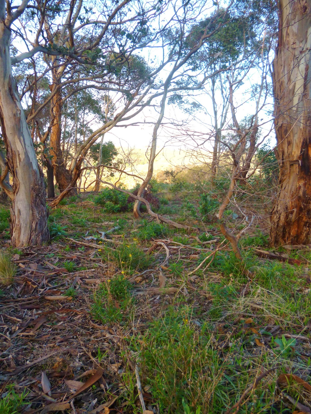
 |
| The beginning of the Circuit trail |

Instead of rain, the clouds dissipated and gave way to clear skies. The morning sun lit up the landscape highlighting and contrasting the scenery.

Because the forest obscured any distant views, my attention was drawn to the finer details of my immediate surroundings, the bright green moss, the regrowth, the bleached-white standing deadwood, and the curious succulent plant peeking through the dead leaves.

Although I hadn't come across any other people, I could still hear the occasional sound of cars on the freeway at this point which detracted from the otherwise remote feel of the experience.
The views from Western Viewpoint were fairly uninspiring, consisting of rolling hills, a farmhouse, and a distant view of the freeway. It did amuse me that the sign denoting "Western Viewpoint 100 meters" was barely 50 meters away. Not much further along is Eastern Viewpoint which in my opinion was much more beautiful and more amusingly only about 15 meters from the 100 meter sign.
 |
| Eastern Viewpoint, Werribee Gorge |
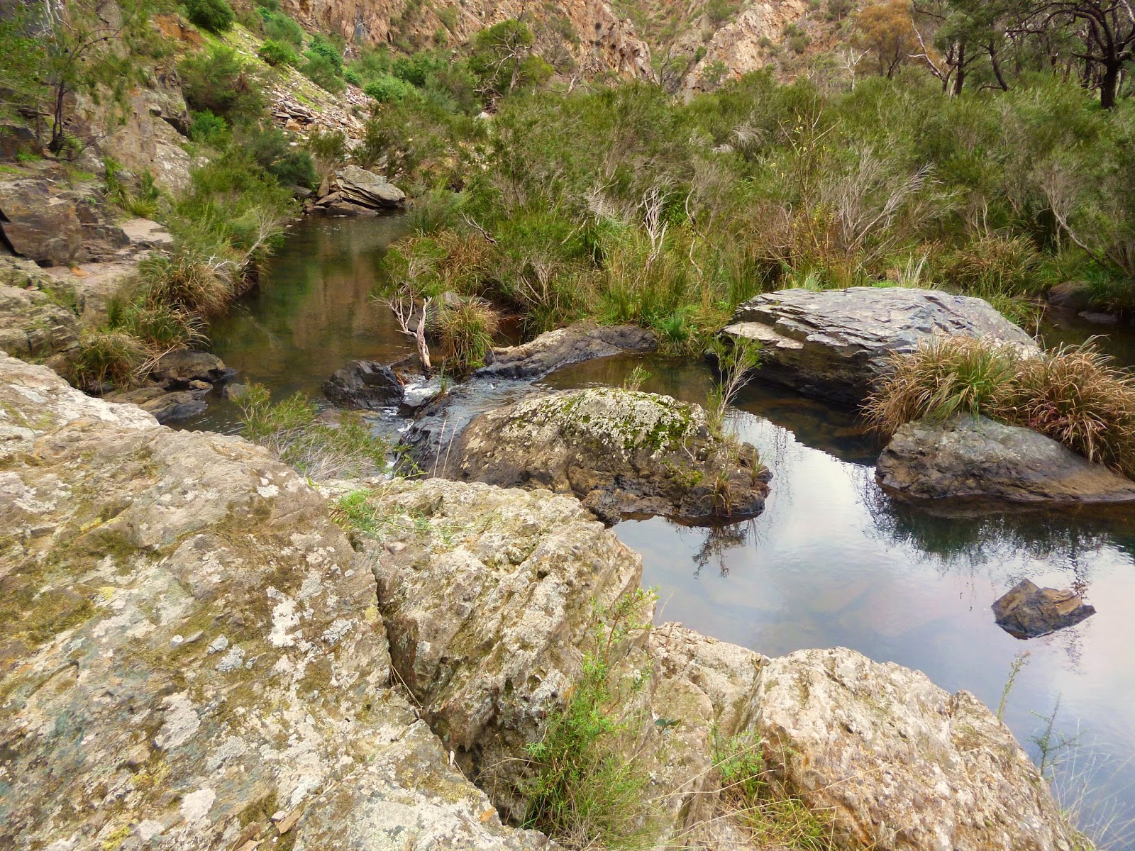
I continued my meandering along to the next point of interest which I think is a highlight of the Circuit. The track leads up to a high-point at the crag of a cliff that affords a wonderful vantage point of the Blackwood Pool.
 |
| Blackwood Pool, Werribee Gorge |

From this point the track led steadily down into the gorge until it was more or less level with the river. The track also became less distinct and more like a bush trail.

The water was mirror-like and reflected the sky, grass, and rocky sides of the gorge.

.jpg) |
A wildflower growing down a rock face
|
The different types of rock lining the ground and cliffs were constantly varied and colourful making for interesting scenery in such a closed in landscape.


This is the Lionhead Beach. Apparently if you look closely you can make out a lions face in the cliff face of the lower right-hand side. I would also say, that if you look closely for long enough, it is more likely that your eyeball will dry out than you will actually see a lion's face. This is not recommended.

Rounding the bend, the path ends and some steel cable anchored to the rock wall mark the way forward. To be honest, the steel cable would have made navigating this section about as fun as a 40km speed limit. Very safe, but not very fun. So I didn't use the cable and went across like people probably have for the last few hundred years, holding on to the rock itself.

.jpg)
After navigating around the rock face, the track quickly moves into a section called the Aqueduct walk. Apparently an industrious farmer back in the early 1900's decided to build a water race along the gorge to irrigate a hundred acres of farmland. The current track is supported by the remains of this concrete wall which makes for a very practical track but in my humble opinion detracts from the wilderness experience.
There was interesting spot along the opposite side of the river that appeared to have been man-made. The picture below shows is of a section about 15-20 metres up a steep cliff, just below a cave-like area, where it looks like a piece of wood has been laid out to cross a gap and then been built up with slabs of rock. There was no obvious path or way up to this spot but I wondered whether it had been constructed to allow access to the cave. I was determined to come back and get a better look another time.

Now the path had become wide enough for an obese and legally blind hipster to trundle along whilst staring intently at their smart phone without coming a cropper. So of course I ran into a small group of aspiring environmentalists, some of whom closely resembled the description of the aforesaid hipster. They giggled inanely as I passed. Apparently it is hilarious when someone says hello to you. I should probably have tweeted or bookfaced my greeting or something.

Now with the hipsters safely behind me. I powered on. Eventually I came to a fork in the road. It wasn't a metaphoric fork in the road causing me to experience a personal crisis about my direction in life, but rather a literal fork in the road. I could either follow the Short Circuit walk to the left, or continue on what I assumed would be the so-called Werribee Gorge Circuit walk. I could not have been more wrong.
I came to Meikles Point carpark where a young guy approached me asking feverishly whether I had recently passed a group of young people. It turned out he was supposed to be with the group but had arrived late. I showed him where I had seen them on my map. It was quite straight forward but he seemed to be struggling with the concept of a map that did not involve GPS and voice commands. I gave him my map and he ran off in search of them. I hope he survived.
I walked on and couldn't find the trail. It seemed to just become a field with no discernible track at all.

After walking around in the field for a while, which was quite pleasant if not very useful, I stumbled upon what looked like a four-wheel-drive track in the general direction I wanted to be going. It led up a steep hill for quite a way until I saw a trail marker ahead. I'm still not sure what track this was. It did lead back to the Quarry Picnic area but it was neither picturesque or interesting which begged the question, why would you put a track here?

Cool account of the walk and I love some of the rock formations. Pretty sure the succulent and wildflower are one and the same, unfortunately named 'Pig Face.' Their usual hangout is coastal areas (you often see it on the sand dunes) and so here is seems to appear a little straggly. It's edible, at least the red fleshy sections are, and good for you. Really salty in coastal areas, I'd be interested to see what it's like further inland.
ReplyDeleteLooking forward to a walk here in the future
Thanks Pete! I wasn't aware of the name of the flower but a quick google search uncovered the fact that this plant is both edible and medicinal. Apparently it has even been used as a cure for Tuberculosis.
ReplyDelete